
Point Cloud Survey in London
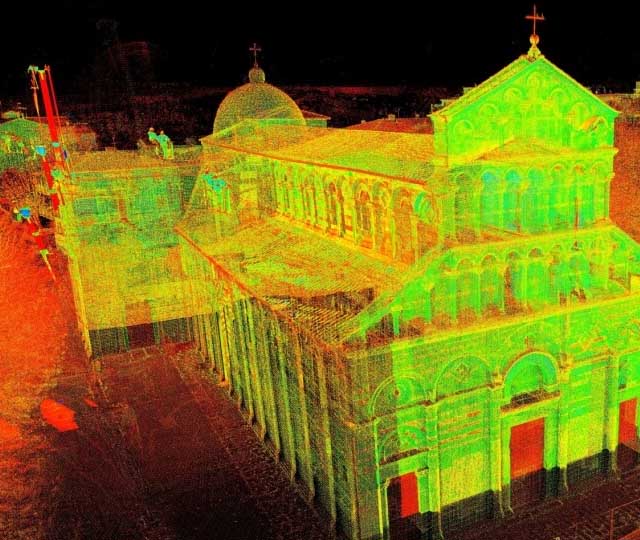
A point cloud refers to a three-dimensional representation of the building’s geometry captured using scanning techniques. It consists of a dense collection of points that collectively form a detailed representation of the building’s surfaces, structures, and architectural elements.
The points represent the coordinates in 3D space of various surfaces and features, such as walls, floors, ceilings, windows, doors, roofs, and structural components. Each point in the point cloud survey London contains spatial information (x, y, z coordinates) as well as potentially additional attributes such as colour, intensity, or reflectance.
Fill Up the Form
Our Services
Land Registry Compliant Drawings
Our Land Registry Compliant Plans can be completed with a fast turnaround to match the legal documents of your property. This includes Freehold Title Plans, Lease Plans, Boundary Plans giving a Comprehensive Service for Property Owners.
3D Laser Scanning
3D Laser scanning is technology used to capture the reality of a site, this can be used in multiple professions. It can be used in our case to map sites and buildings, or it could be used to capture a traffic accident so forensics could return to the scene years later from a PC.
Drone Surveys
Inspect roofs, document developments, or conduct property surveys with a high level of detail and in record time. That’s the power of drone imagery and videos.
Topographical Surveys
Topographical surveys are land surveys that measure and map a piece of land’s physical features and characteristics. These features may include the terrain’s elevation, contours, vegetation, water features, and man-made structures.
MEP Design
Dedicated to pioneering solutions and streamlined project execution. We can assist with Building information modelling, BIM management, BIM to scan, M&E design consultancy, clash detection, COBie / Asset Data management and much more.
Title Plans
We specialise in providing accurate and detailed Land Registry Compliant Title Plans tailored to meet your specific requirements. Our team of experienced professionals understand the importance of precision and compliance when it comes to land documentation.
Unveil the Architecture with Redefined Precision
Bidston Draughting is your trusted companion for measured building surveys and point cloud solutions. With years of expertise in advanced 3D laser scanning, we cater to diverse industries, providing precise point cloud data for project development, planning, archiving, and quality inspection.
Our meticulous approach ensures detailed and accurate results, eliminating risks of error. Whether you need greyscale or coloured point clouds, our integrated camera delivers tailored solutions. Experience the power of our technology and team, empowering your workflow with efficiency and productivity.
What Are the Benefits of 3D Point Cloud?
Experience the efficiency and accuracy offered by our 3D point cloud solutions. Trust Bidston Draughting to transform your projects using advanced point cloud technology.
- Save time and money by streamlining project workflows, minimising errors, and optimising resource allocation.
- Capture intricate details of objects and environments with accuracy, allowing for informed decision-making and precise analysis.
- Ensure seamless transition between 2D and 3D representations, enabling comprehensive visualisation.
- Utilise reliable and accurate point cloud data as a starting point for creating detailed 2D drafts and immersive 3D models.
Convert point cloud data into compatible formats for popular software applications such as CAD, Revit, Vectorworks, SketchUp, and more.
We can help you get the surveys and drawings that you need for your projects.
Our draughting team are ready.
Get Point Cloud Data in the Following Formats
At Bidston Draughting, we provide you with the flexibility to obtain point cloud data in various formats, catering to your specific needs:
FLS – Exported from Faro Scene, this format allows for efficient storage and retrieval of point cloud data.
PTS, PTX – These formats are primarily exported from Leica Cyclone after the registration process is completed. They can also be exported from Faro Scene, providing versatility and compatibility.
E57 – As a compact and vendor-neutral format, E57 ensures optimal storage of point cloud data while maintaining compatibility across different software platforms.
RCP – Used in AutoCAD/Revit, the RCP format is ideal for producing 2D drawings and 3D models, enabling seamless integration into your existing workflows.
What Deliverables Do We Offer?
At Bidston Draughting, we offer a comprehensive range of deliverables that leverage the power of 3D laser scanning and point cloud technology. Our deliverables include:
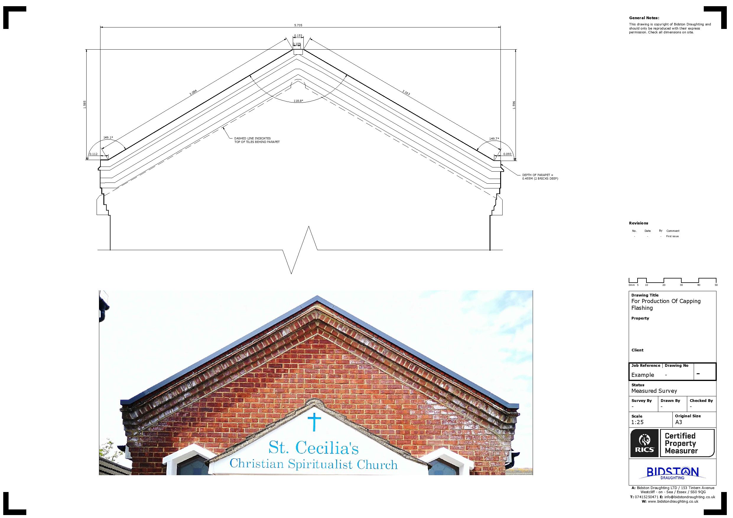
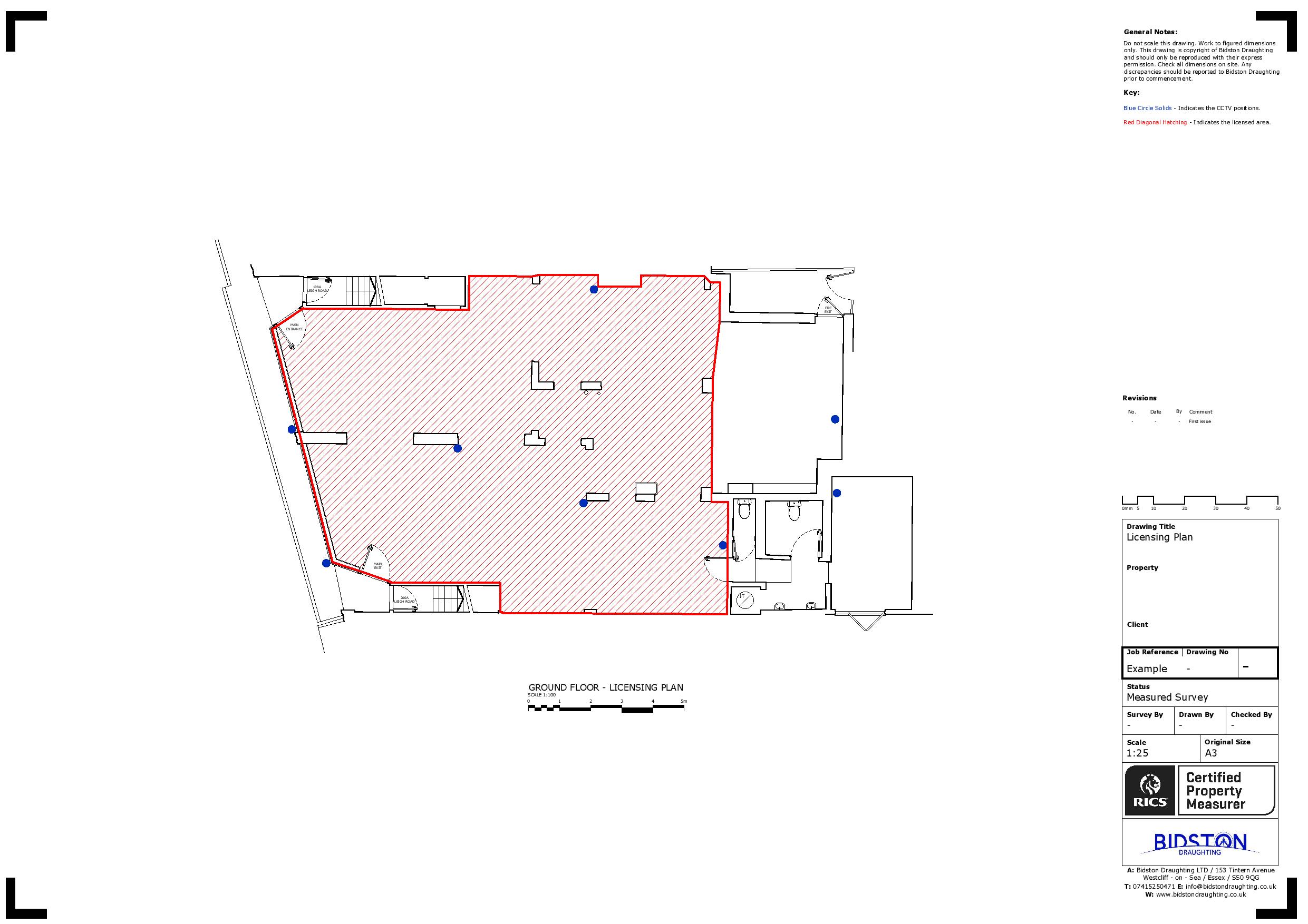
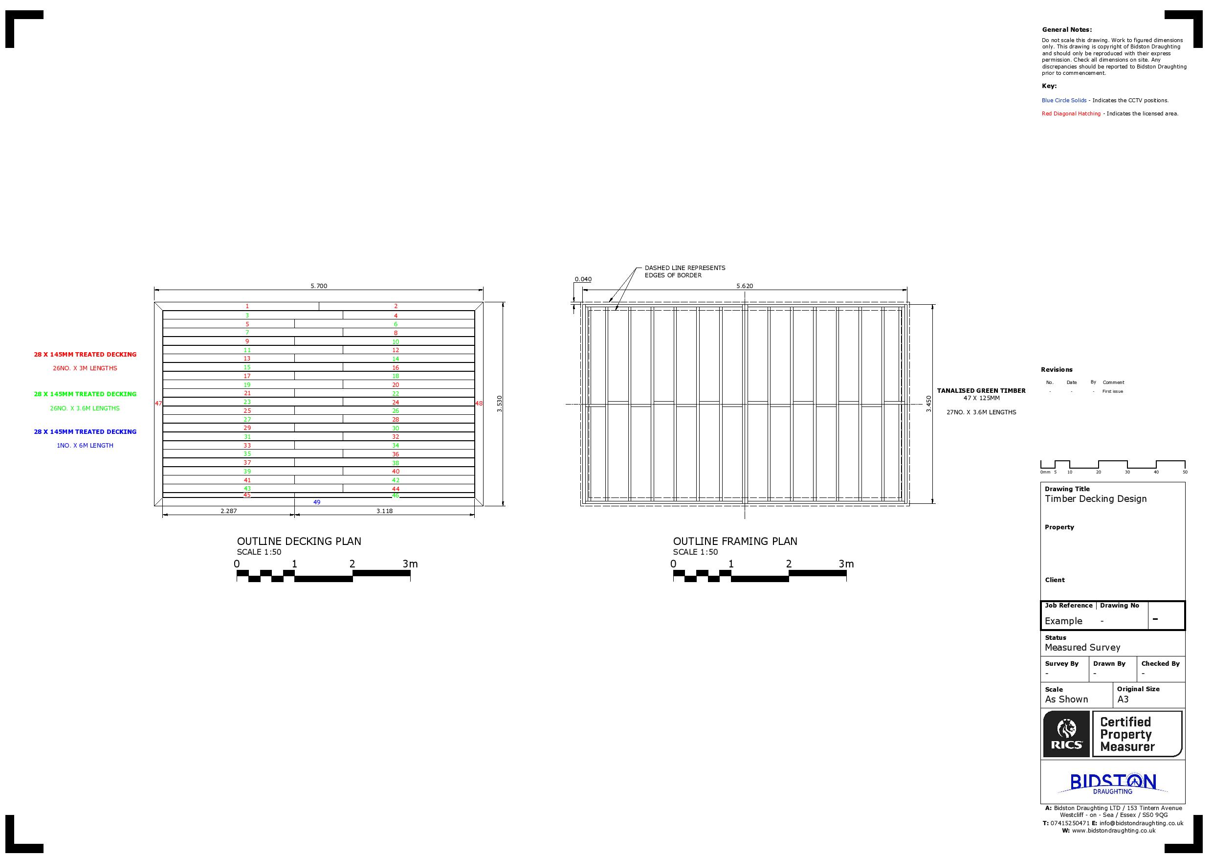
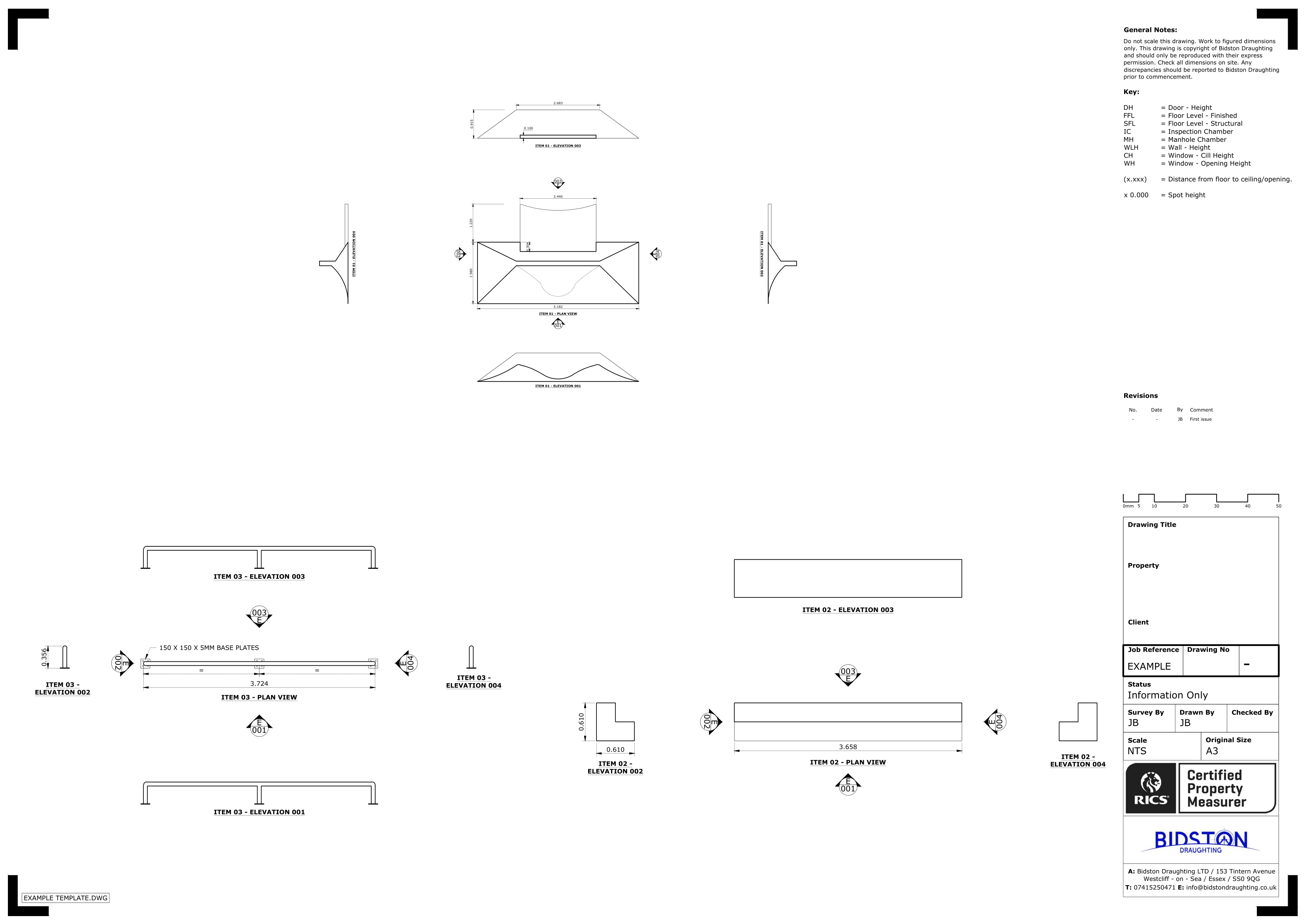
2D Drawings – Using AutoCAD software, we create accurate and detailed 2D drawings, encompassing floor plans, roof plans, cross-sections, and elevations.
Floor Plans – We generate precise floor plans based on point cloud data, ensuring an accurate depiction of the building’s layout and dimensions.
Roof Plans – Our team creates detailed roof plans that showcase the roof structure, including slopes, ridges, valleys, and other relevant architectural elements.
Cross-Sections – We produce cross-sectional views that allow for in-depth analysis of the building’s internal structures, enabling effective evaluation and optimisation.
Elevations – With our expertise, we generate elevations that accurately depict the building’s exterior facades, capturing architectural features, fenestrations, and other critical details.
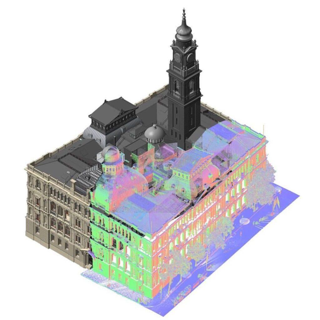
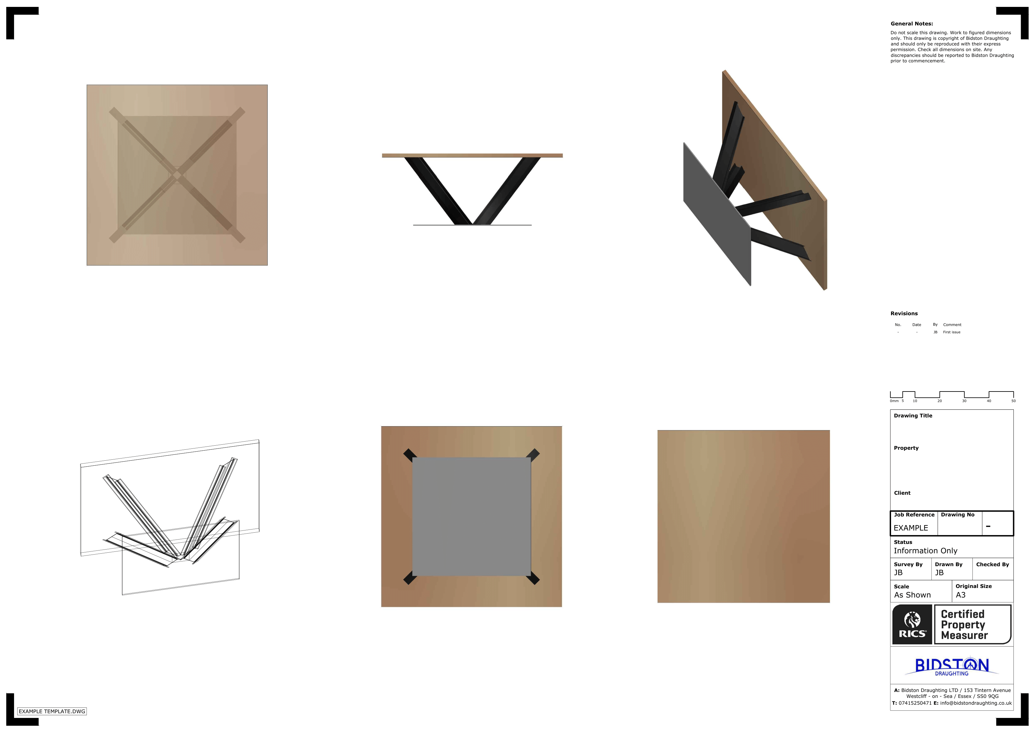
3D Revit Models – We can acquire 3D Revit models based on point cloud data, serving as a valuable tool for analysing and optimising building performance.

When Do You Need a 3D Point Cloud Survey?
At Bidston Draughting, we carefully evaluate your project requirements to determine the necessity of a point cloud Survey. Typically, we recommend utilising point cloud surveys for the following scenarios:
- Existing Building Renovation – When renovating, point cloud survey provides an accurate representation of the building’s current state, enabling precise measurements and facilitating effective design and planning.
- New Building Development – Before new construction, it captures the existing environment, aiding site analysis, design integration, and ensuring architectural compatibility with nearby structures and features.
- As-Built Structure Verification – Verifying construction against the planned design is essential. This survey captures the as-built structure, enabling detailed comparisons and ensuring compliance with architectural plans.
FAQs
How Do We Capture the 3D Point Cloud?
To capture the 3D point cloud, our process involves aiming the scanner at the desired area or object, collecting millions of measured points. These points are then processed and registered using specialised software.
What Can I Do with the Data from My Point Cloud?
Point Clouds offer a visual representation of raw scanned data. While the initial points may lack visual quality, they can be utilized in CAD designs for efficient 3D modelling.
You use Point Cloud data for heritage conservation, accurately mapping architectural properties to maintain, conserve, and restore sites effectively.
Why is a 3D Point Cloud Service Used?
Using a 3D point cloud service eliminates human error in measurements, thanks to high-quality and advanced surveying equipment. This ensures accurate and precise results for measured building surveying, reducing risks and improving efficiency.
What Can You Do with a Point Cloud?
A point cloud offers various applications, leveraging its accuracy, non-contact nature, and increased efficiency. It can be used to create Building Information Models (BIMs) for optimised development, design, and construction project management.
Bidston Draughting Ltd
Providing measured surveys throughout Essex, Kent and Greater London. Our full operations can take place anywhere in the UK and Europe, please get in touch to discuss your project.
We are insured up to £1M for public liability and professional indemnity.
Contact us Now
T: 020 3576 1705
E: info@bidstondraughting.co.uk
Offices
E: london@bidstondraughting.co.uk
E: essex@bidstondraughting.co.uk
E: kent@bidstondraughting.co.uk
VAT No. - 462695853