Blog

Point Cloud Survey: Time Saving, Cost-Effective & Accurate

By August 17, 2023August 22nd, 2023No Comments

Point Cloud Survey

With time, new and innovative techniques, methods and criteria are developed that have revolutionised the technical approach of man to construction. These new approaches are opening up new ways for mapping, site analysis, building configurations, planning and construction.

Primitive techniques like Theodolite Surveying, Photogrammetry and conventional LiDAR were time-consuming, and yet they did not prove to be much effective.

These techniques were inefficient in giving a detailed overview of the structure of a building. Moreover, they gave a 2D analysis, thus limiting the experts to think and plan their construction project more comprehensively.

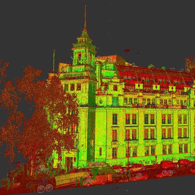
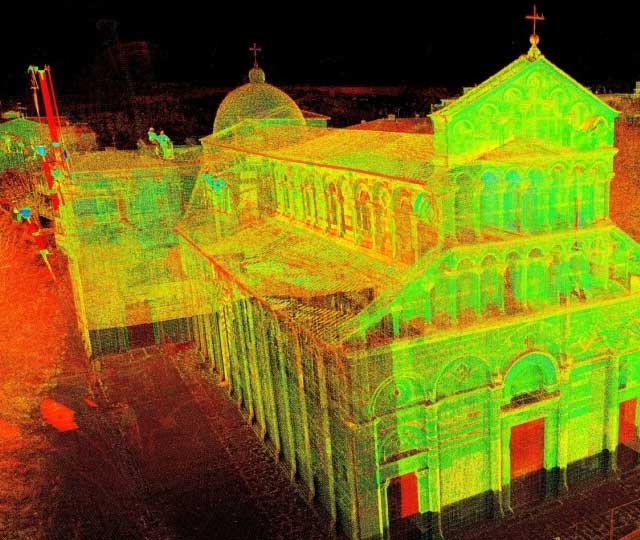
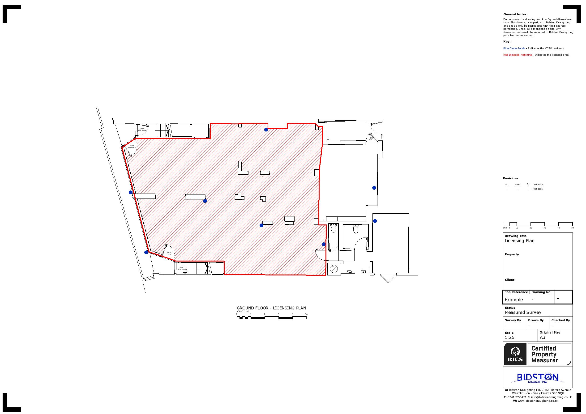
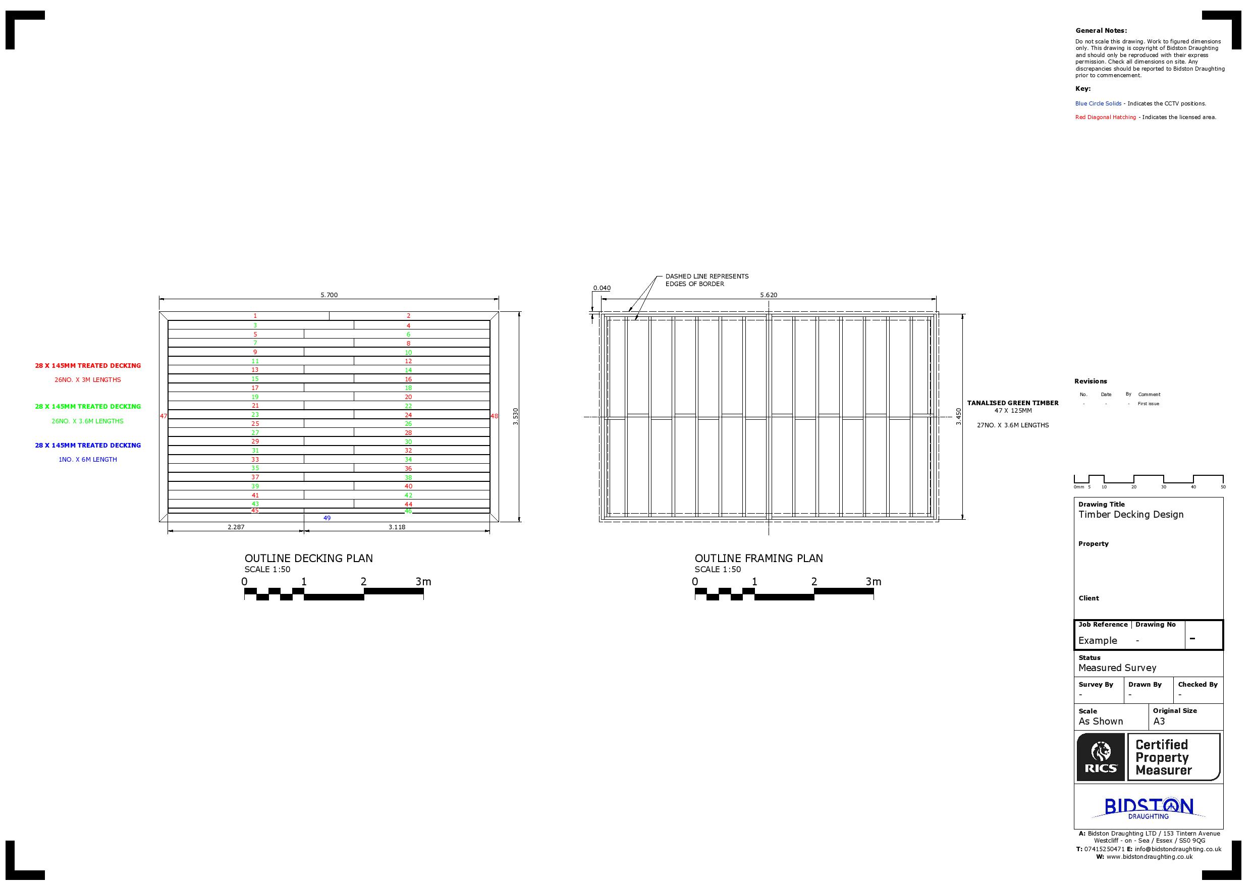
These limitations gave rise to modern 3D mapping techniques giving pinpoint details of a structure, its geometry, space orientation and other key details. Among advanced 3D scanning techniques is Point Cloud Survey. Let’s discuss the details.

What is Point Cloud Survey?

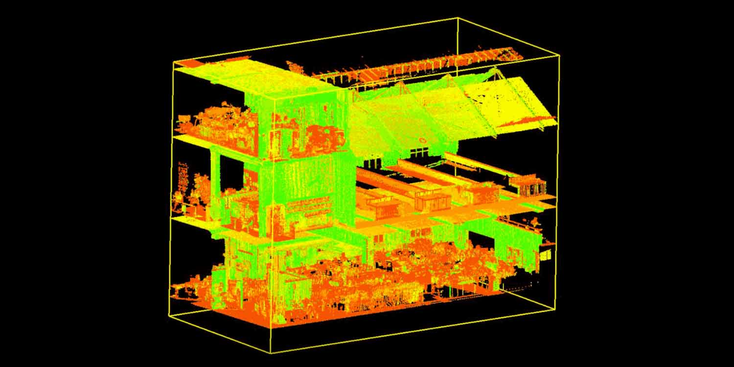
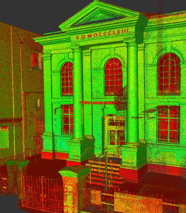
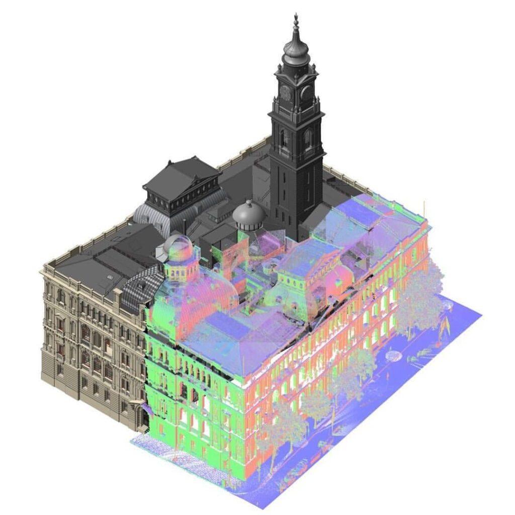
A point cloud survey is a laser technique that scans a structure to get detailed data points or coordinates in 3 dimensions.  These points are then interpreted using suitable software like Cloud Compare, Meshlab, Gom Inspect, etc., to get a whole picture of the building.

What is Point Cloud Servey..
How does it works...

How Does It Work?

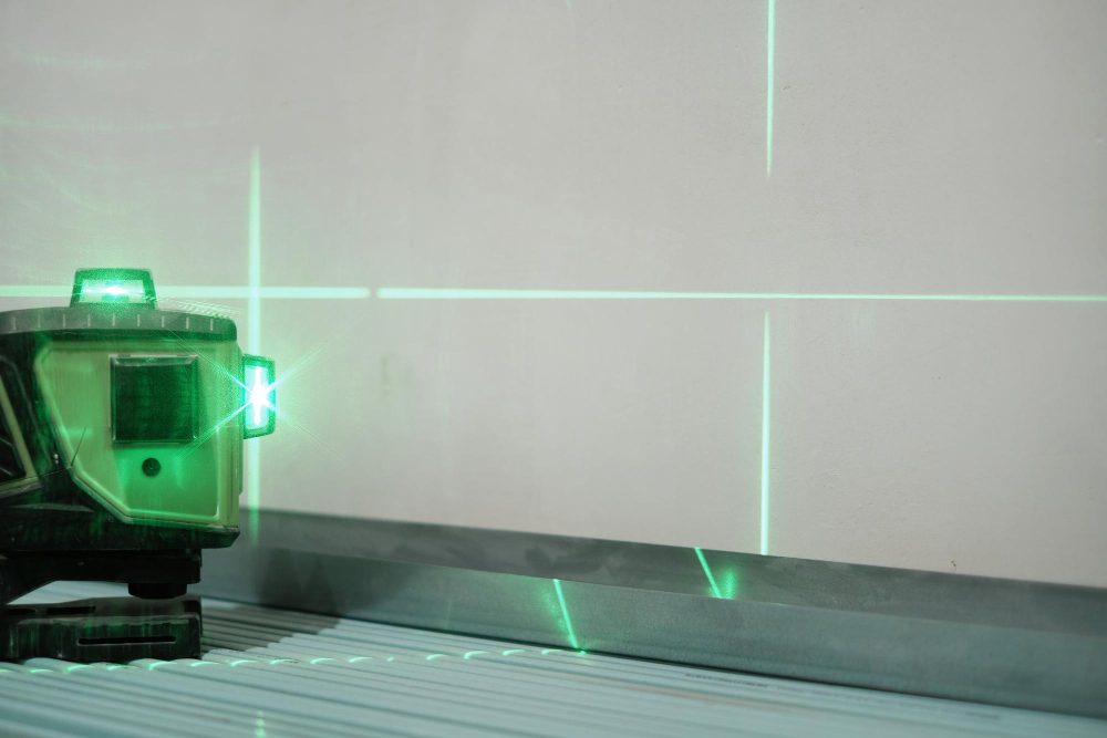
Unlike conventional techniques, the Point Cloud survey clarifies a whole new structure. A laser emitting thousands of beams scans the building for these detailed analyses. The beam hits the surfaces at different angles and returns points as they hit surfaces.

Each point has information in its X, Y, and Z coordinates, whereas the information reveals the distance it has travelled. These points are combined using specialised instruments and softwares to extract the required information.

Evolution of Point Cloud Survey?

Earlier in the beginning, point cloud surveys began as Geographical Information systems (GIS) that were first introduced in the 1960s to analyse the data for mapping purposes.

However, in 1990, GIS was used to investigate accidental sites other than terrain analyses. In 2010, GIS was used in 3D models from point clouds. This laid the foundation of a point cloud survey for detailed point structural analyses.

How is Point Cloud Survey Advantageous to Old Techniques?

Being one of the latest mapping techniques, the point cloud survey is advantageous in many aspects. Let’s see how it’s different from old techniques and how it can assist us in saving our quality time and generating accurate results.

Unmatched Accuracy:

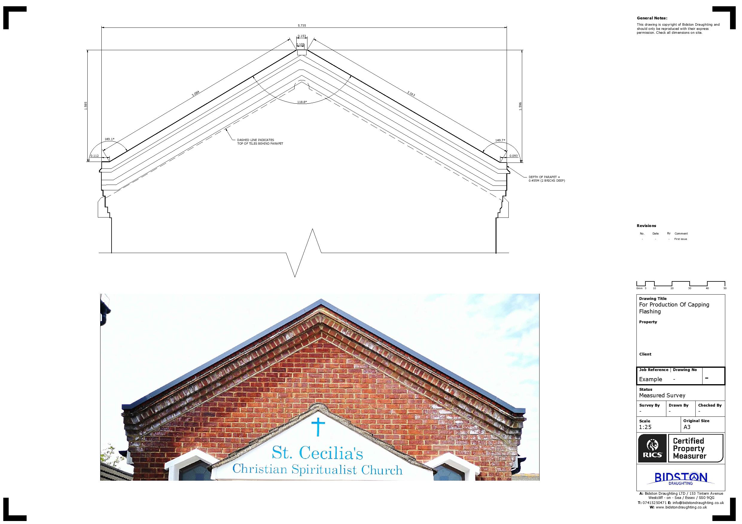
Unlike conventional techniques, 100 % accuracy is one of the prime features of a point cloud survey. With a detailed analysis, even in millimetres, point cloud surveys eliminate the probability of errors in mapping. When applied to real-world projects, these accurate mapping results give better cost control as any expected issue can be rectified timely, thus saving time, cost and energy.

Enhanced Visualisation:

Multiple complex projects include retrofitting facilities and require accuracy in every aspect, whether floor elevations, ceiling pans, cover sheets, etc.

A point cloud survey with an accuracy range of +/- 10mm can help clients achieve 360-degree visualisations, meaning greater details and a more accurate building structure per the client’s demands. This enhanced visualisation ensures precision in the project.

Enhanced Visualization
Easy & affective Access

Limited Site Revisits:

Using primitive techniques, contractors have to visit the site many times to collect the information missed in every visit. Contrarily, a point cloud survey enables them to collect all the details effectively in a single attempt using laser technology. Thus, it saves time, allowing you to focus on key aspects of the project.

Limited Man Force:

Earlier techniques demanded more labour and equipment for a site analysis. This was not only costly, but also there were chances of human error.

Along with these drawbacks was the availability of skilled staff to conduct a site analysis for accurate mapping. However, with the advent of point cloud surveys, these hassles are wiped out and a right, directional and precise site analysis possible with minimum human intervention and cost.

Easy and Effective Access:

At times, there are minute or confined structures inaccessible to analyse via old techniques; however, a point cloud survey allows access to the smallest points on a structure. Hence, it gives you greater and easy access to limited sites.

Safety for Sensitive Structures:

Point cloud surveys are non-destructive and do not require physical contact with objects or terrain. This eliminates manual probing or excavation, which can be time-consuming and costly.

Higher Work Efficiency:

Giving detailed collaborative structures, cloud point surveys enable the contractors and the experts to work more easily. In the term, this increases work efficiency and ultimately enhances the speed of project completion.

Higher Work Efficiency
Versatile Applications

Versatile Applications:

Cloud Point Survey holds its key significance in being a multifaceted technique applicable in many ways. Whether there is a need to create accurate models of a building or generate a replica of any complex part of a machine, a cloud point survey remains relevant.

This technique can also be used to analyse and interpret the structures of historical sites. Moreover, cloud point surveys can be helpful to study the topography of mountains and caves, investigate the details of crime scenes, and create animated characters and scenes in games. None of the primitive techniques is multi-dimensional enough to serve these purposes.

Conclusion

Being innovative, helpful, and effective in giving detailed analyses, enhanced visualisation and 100% pinpoint accuracy up to millimetres, cloud point survey remains a multi-dimensional technique with numerous applications in mapping, structural analyses and investigations.

With a precise blend of laser technique with digitalisation, this technique has made the work easy, speedy and collaborative. Due to these reasons, cloud point survey outshines the primitive mapping methods.

Point Cloud Survey

Bidston Draughting LTD is a renowned company offering top-notch point cloud survey services throughout London and the UK. A point cloud survey consists of collecting millions of accurate measurement points with advanced technology. Ideal for architects, engineers, contractors, and property professionals who require reliable data for design and planning to support complex projects.

Fill Up the Form

What Is Point Cloud Laser Scanning?

Point cloud laser scanning is a surveying technique that utilises laser technology to collect millions of 3D data points, resulting in a precise digital 3D model of the environment. Each data point is plotted along X, Y, and Z coordinates of a surface within the scanned three-dimensional space, allowing for millimetre-precise measurements.

How Accurate Is It?

Point cloud laser scanning is highly accurate, which typically achieves accuracy levels of ±2mm to ±5mm under optimal conditions. However, this accuracy may fluctuate based on factors like equipment quality, surveyor skill, and site conditions.

How Much Does It Cost?

The cost of point cloud laser scanning typically ranges between £500 and £5,000 or more. Prices can vary based on a number of factors, including the size of the land being measured, the required level of detail, and the complexity of the environment.

When Do You Need a Point Cloud Survey?

A point cloud survey is essential for all scenarios where high-precision and 3D digital data are paramount, including:

  • Refurbishment and renovation projects
  • Clash detection and coordination
  • Site layout and positioning
  • Placing CAD and BIM models
  • Design coordination and collaboration
  • Construction planning and sequencing

Professional Point Cloud Scanning Services

At Bidston Draughting LTD, we provide high-precision point cloud laser scanning services to capture and deliver detailed 3D data of buildings, environments, and structures. Using advanced terrestrial laser scanners, LiDAR, and photogrammetry, we deliver accurate, millimetre-level point clouds, CAD, and 3D BIM models to support planning, design and construction.

Our Services

Land Registry Compliant Drawings

Our Land Registry Compliant Plans can be completed with a fast turnaround to match the legal documents of your property. This includes Freehold Title Plans, Lease Plans, Boundary Plans giving a Comprehensive Service for Property Owners.

3D Laser Scanning

3D Laser scanning is technology used to capture the reality of a site, this can be used in multiple professions. It can be used in our case to map sites and buildings, or it could be used to capture a traffic accident so forensics could return to the scene years later from a PC.

Drone Surveys

Inspect roofs, document developments, or conduct property surveys with a high level of detail and in record time. That’s the power of drone imagery and videos.

Topographical Surveys

Topographical surveys are land surveys that measure and map a piece of land’s physical features and characteristics. These features may include the terrain’s elevation, contours, vegetation, water features, and man-made structures.

MEP Design

Dedicated to pioneering solutions and streamlined project execution. We can assist with Building information modelling, BIM management, BIM to scan, M&E design consultancy, clash detection, COBie / Asset Data management and much more.

Title Plans

We specialise in providing accurate and detailed Land Registry Compliant Title Plans tailored to meet your specific requirements. Our team of experienced professionals understand the importance of precision and compliance when it comes to land documentation.

Point Cloud Survey

What You Receive from Our Point Cloud Surveys

We combine our extensive surveying expertise with advanced 3Dpoint cloud laser scanning technologies to deliver accurate, reliable data for a range of projects. Here’s our offerings:

2D Drawings: We produce clear, accurate line drawings from the survey data, capturing essential structural and spatial details for design and documentation.

Floor Plans: Our engineers deliver detailed overhead layouts for each level, showing room dimensions, wall positions, and key architectural features.

Elevations: We create precise vertical views of building exteriors or interiors by highlighting heights, openings, and facade details.

3D/BIM Models: We develop intelligent three-dimensional models that integrate geometry and data to support efficient planning, analysis, and coordination across BIM workflows.

When Do You Need a Point Cloud Survey

Point cloud surveys are essential for projects requiring high-precision data and accurate digital modelling. Here are the key ways that this technology can be utilised:

Renovations and Refurbishment Planning: Our point cloud surveys help you ensure that design plans are grounded in real-world conditions. They support precise renovation planning, whether you’re updating office spaces or converting industrial warehouses.

BIM Modelling: Our point cloud laser scanning services are designed to integrate seamlessly into BIM workflows, providing accurate, detailed inputs for clash detection, design updates, and facilitating management.

Heritage Documentation: To maintain an accurate digital record of historic buildings for restoration, repair, or academic research, our surveys offer a non-invasive way to capture every detail, ensuring meticulous accuracy.

Designing New Construction Projects: We offer point cloud surveys that are highly valuable in the early stages of construction. Our surveys provide a detailed 3D model of the existing site conditions to ensure a project gets off the ground with a strong foundation of accurate data. 

We can help you get the surveys and drawings that you need for your projects.

Our draughting team are ready.

Point Cloud Survey in London

Industries That Use Point Cloud Surveys

Construction and Architecture – Point cloud surveys generate 3D models of the construction site, helping engineers visualise and plan projects better. Our surveyors identify issues early and ensure timely project completion.

Engineering – Reverse engineering is an essential technique that utilises laser scans to generate digital models of existing parts or products. This allows companies to innovate and improve their products more effectively.

Infrastructure – Point cloud surveys generate detailed 3D digital models of environments by collecting millions of data points with millimetre accuracy. In infrastructure, this technology provides an accurate “as-built” record, speeding up projects, reducing human error, enhancing safety, and cutting costs.

Our Work

Our Point Cloud Survey Process

Site Visit

Our team performs a site visit to assess your property’s renovation needs and the necessary level of detail. This helps us determine our approach.

Laser Scanning

Our trained surveyors use laser scanning or LiDAR devices to perform a point cloud survey, positioning the scanner on a tripod at various strategic points around the site. The scanner rotates while emitting a laser beam that quickly measures millions of points, capturing everything within its line of sight.

Data Processing

 After scanning, our surveyors use specialised software to clean and optimise the raw data for export in the required format, ensuring complete coverage of the designated scan area.

Model Creation

Prioritising your requirements, we deliver 2D drawings, elevations, 3D models and BIM files. We ensure our outputs are highly accurate and ready to support a range of design, planning and construction projects.

Benefits of Our Point Cloud Surveys

Our point cloud laser scanning services are designed to:

  • Provide highly accurate and dependable measurements for confident decision-making.
  • Save valuable time and help capture comprehensive data quickly and efficiently.
  • Reduce errors by minimising the need for repeated site visits and manual measurements.
  • Improve cost efficiency by streamlining workflows and avoiding unnecessary rework.

Software & Formats We Support

We use advanced software to deliver the data in your preferred format, tailored to your project requirements. Here’s the software and formats we support:

  • AutoCAD: We deliver precise 2D drawings fully compatible with AutoCAD workflows.
  • Revit: Our surveyors provide intelligent 3D models ready for seamless use in Revit.
  • BIM: We support BIM processes with data-rich models for coordination and analysis.
  • File Formats: Our professional team supplies point cloud data in industry-standard formats such as E57 and RCP, for easy integration.
Point Cloud Survey

Why Choose Our Point Cloud Survey Services

When it comes to point cloud surveys, working with Bidston Draughting LTD means you receive precise, reliable data delivered efficiently and professionally. We integrate industry expertise, cutting-edge technology, and a client-centric approach to produce high-quality results, guaranteeing each project meets the highest standards.

Our experienced team is always available to assist you in determining which survey type will provide the greatest value for your project. Whether that’s a full 3D point cloud, Laser Scanning, BIM Services or a traditional Measured Building Survey.

Here are the reasons to partner with us:

  • Experienced team with extensive knowledge across a wide range of projects
  • Fast turnaround times to keep your project moving without delays
  • Highly accurate data you can trust for design and decision-making
  • Nationwide UK coverage to support projects wherever you are
Point Cloud Survey

Ready To Bring Certainty to Your Project?

At Bidston Draughting LTD, point cloud technology transforms how we capture and build environments. Our expertise and experience make us a trusted choice for delivering precise accuracy and comprehensive insights. We are consistently available to offer professional advice tailored to your specific needs.

Secure the future of your project with us—reach out today for a free, no-obligation quote, and together we’ll transform your vision into reality with confidence.

FAQs

Our point cloud surveys are used to create accurate 2D drawings, floor plans, elevations, and 3D/BIM models, supporting design, planning, refurbishment, and asset management.

Point cloud data is highly accurate, typically within ±2–5 mm, and captures all visible elements, depending on the equipment and site conditions.

The timeframe for point cloud surveys depends on several factors, including project size, site accessibility and complexity, and the required level of detail. However, data capture is typically quick, with processing and deliverables completed within days or a few weeks.

We offer point cloud scanning services to collect highly accurate data that can be used widely in construction, architecture, engineering, and infrastructure projects, ideal for renovations and refurbishments.